 |
Plans and Studies |
 |
Delaware County's newest study relating to trails is the Delaware County Open Space, Recreation, and Greenway Plan, adopted by Delaware County Council in April, 2015. This plan features detailed improvement plans for the major county-owned parks, and it also puts forth a conceptual county greenway/trail network that is one level more local than "The Circuit" multi-county regional trail network. This study is posted on the Delaware County website: www.delcopa.gov/planning/pubs/delco2035/OpenSpaceandRecreationPlan.html |
 |
In 2011 Upper Darby Township produced the Naylors Run Trail Feasibility Study. This trail would make use of the former route of the Newtown Square Branch, a local freight rail line of the old Pennsylvania Railroad. PECO owns the right-of-way today, having placed power lines along the branch railroad when it was still operating. This trail concept has great possibilities to offer recreational opportunities to the many people that live along it in the north-south central Upper Darby corridor, as well as safer, traffic-free access by bike or foot to Upper Darby High School and Naylors Run Park. You can read the study
here. |
 |
The Delaware County Planning Department issued a Darby Creek Stream Valley Park Master Plan in 2009. This plan studies in detail the possibility of creating a continuous multi-use trail along the Darby Creek "greenway." Part of this trail would run along the western edge of Upper Darby, where it borders Springfield Township. There are numerous parklands and other sites already in township and county ownership along Darby Creek. In addition, Delaware County is moving forward, with grant funding in hand, to construct the first part of this trail within Upper Darby. This section will connect the county's Kent Park with the site of the historic Swedish Cabin further upstream. You can find this study on the Delaware County website: www.delcopa.gov/planning/pubs/DarbyCreekStreamValleyParkMasterPlan.html |
 |
In 2009 Delaware County issued the Delaware County Bicycle Plan, prepared by its Planning Department. This plan sets forth a recommended prospective network of bicycling facilities throughout the county. You can read it on the county website: www.delcopa.gov/planning/pubs/BicyclePlan.html |
 |
Upper Darby Township updated its Upper Darby Comprehensive Plan in 2018. The township comprehensive plan is intended to serve as the official guide to shaping future development and improvements in the township. You can read it on the township website: www.upperdarby.org/businesses/comprehensive-plan |
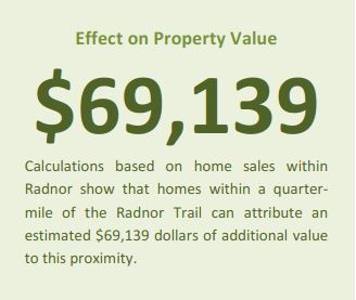 |
The Economic Value of Protected Open Space in Southeastern Pennsylvania is a fascinating study conducted in 2010 for The Delaware Valley Regional Planning Commission (the multi-state regional planning organization for the Greater Philadelphia area) and the GreenSpace Alliance by the Economy League of Greater Philadelphia, Econsult Corporation and the Keystone Conservation Trust. The researchers conducted seven case studies, using various open space and trail locations in southeastern Pennsylvania, to determine various economic benefits of them. All but one had positive economic benefits, and the exception was determined to essentially be statistically a "wash." It found that the Radnor Trail raised home property values by $69,139 within a quarter-mile of the trail, compared to comparable Radnor Township homes farther than a quarter-mile from the trail. You can read the study on the DVRPC website: www.dvrpc.org/openspace/value/pdf/OpenSpaceReport-FirstEdition.pdf |